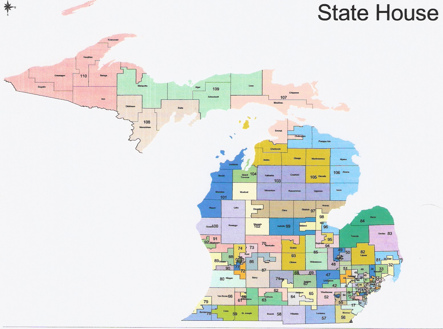
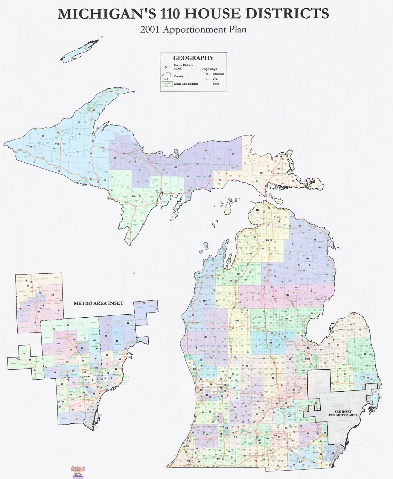
For comparison, here is the current state house map.
This author has previously proposed a state house redistricting plan broken into four parts. The basic rules that any plan must satisfy are explained in the first article.
Many sections of this map are quite similar to the current map, particularly Southwest, south-central, UP, the Thumb, and south Oakland. Wayne loses almost three house districts, with most of the losses coming from Detroit. These are distributed to other parts of the state. Roughly speaking, the new seats are in central Macomb, Ann Arbor suburbs, and Grand Rapids suburbs. Other demographic changes were smaller, and are detailed in the fourth article above.
Overall, this map breaks 23 counties, including three double breaks (St. Clair, Kent, Kalamazoo). The current map breaks 24 counties with two double breaks (St. Clair, Ottawa). My proposed map breaks 22 counties, including three double breaks (St. Clair, Jackson, Kalamazoo).
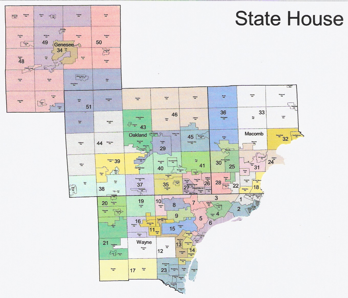
This map also breaks 18 cities/townships, including breaking Detroit seven (!) ways, and a triple breaks in Warren. These breaks are in Wayne (7), Macomb (5), Oakland (3), Flint, Ann Arbor, and Lansing.
The current map breaks 17 cities/townships, including a triple break for Detroit. These breaks are in Wayne (6/8), Macomb (4), Oakland (2), Genesee (2), Ann Arbor, Lansing, and Grand Rapids. My map breaks 13 cities/townships, including breaking Detroit four ways and two double breaks (Sterling Heights, Clinton Twp). These breaks are in Wayne (5/8), Macomb (3/5), Oakland (2), Flint, Ann Arbor, and Lansing.
There are 12 black-majority districts, ten based in Detroit, and one each in Southfield and Flint. This is the same as the current map despite population loss in Detroit.
DISTRICT DESCRIPTIONS
We provide proposed district number, corresponding current district number, political rating, and geographic description.
-10. (1-12,17) Safe D [Detroit]
(16) Safe D [Inkster, Garden City]
(22) Safe D [Taylor, Romulus]
(?) Safe D [Southgate, Allen Park, Dearborn Heights]
(13) Safe D [Riverview, Wyandotte, Lincoln Park, Melvindale]
(15) Safe D [Dearborn]
(18) Safe D [Westland, Wayne]
(56) Tossup [N Monroe, Sumpter, Huron]
(24) Safe D(---) [St. Clair Shores, Eastpointe]
(19) Safe R [Livonia]
(20) Safe R(++) [Plymouth, Northville]
(21) Tossup [Canton, Van Buren]
(42) Safe D [Roseville, E Warren]
(23) Tossup [SE Wayne]
(new) Safe R(++++) [Harrison, N Clinton, SW Macomb]
(25) Tossup(++) [E Sterling Heights, NC Warren]
(26) Safe D [Royal Oak, Madison Heights]
(27) Safe D [Oak Park, Ferndale, Hazel Park]
(28) Safe D [W Warren, Center Line]
(29) Safe D [Pontiac, Auburn Hills, Orchard Lake]
(30) Safe R [W Sterling Heights, Utica, SE Shelby]
(31) Safe D [S Clinton, Fraser, Mt. Clemens]
(32) Lean R [Chesterfield, C St. Clair]
(33) Safe R [NE Macomb, Macomb Twp.]
(34) Safe D [Flint]
(35) Safe D [Southfield]
(36) Safe R [Shelby, Washington, Bruce]
(37) Safe D [Farmington]
(38) Safe R [Novi, Lyon]
(39) Lean R(+) [W West Bloomfield, Commerce, Wixom]
(40) Safe R [Bloomfield, Birmingham, E West Bloomfield]
(41) Safe R [Troy, Clawson]
(66) Safe R [SE Livingston]
(43) Safe R(+) [Waterford, Independence]
(44) Safe R [Springfield, White Lake, Highland, Milford]
(45) Safe R [Rochester, S Oakland Twp]
(46) Safe R [NE Oakland]
(47) Safe R [N Livingston]
(?) Lean D(+) [Genesee W tier, Fenton, Mundy]
(48) Safe D [Flint Twp., Mt. Morris, Vienna, Thetford]
(50) Safe D [Burton, Genesee, Davison, Richfield, Forest]
(51) Safe R(+) [Grand Blanc, Fenton, NW Oakland]
(52) Lean R(++) [W Washtenaw]
(53) Safe D [Ann Arbor]
(54) Safe D [Ypsilanti]
(new) Lean D(+) [Pittsfield, NE Ann Arbor, York, Augusta]
My initial reaction to this map was negative. Having analyzed it, I'm a little more favorable, but there are still some real problems. It appears that excessive consideration was given to protecting existing incumbents. But this makes little sense when they will all be term-limited out of office by 2016 at the latest. It is selfish to put short-term incumbents ahead of the long-term interests of the party.
On the plus side, Republicans will gain two of the three new seats that Wayne lost. Various other districts are shored up in
* Plymouth/Northville (loses Wayne)
* Waterford (loses N W Bloomfield, S Waterford)
* W Washtenaw (loses NE Ann Arbor)
* SW Kalamazoo (loses W Kalamazoo Twp)
* S Berrien (loses Dowagiac)
* Shiawassee (loses Bath)
* Clare/Gladwin (loses N Bay)
* NC LP (adds Kalkaska)
Districts are made more competitive in
* West Bloomfield (loses S West Bloomfield)
* Sterling Heights/Warren (adds more of Sterling Heights)
* S Ingham (trades precincts in Lansing)
* Peripheral Grand Rapids (adds W Grand Rapids)
Here are the problems.
The map does not comply with the Apol standards as well as either the current map or my proposed map. While the number of county breaks are close in all three, the number of city/township breaks is much larger in the proposed map. This is despite the fact that the map is less favorable to Republicans than my map.
Pat Summerville is cut out of his Wayne southern tier district and given largely new territory in Monroe. Most of the territory he won is without an incumbent.
There could easily be another lean R district in the Oakland/Genesee area. The proposed map gives Paul Scott a safe district, but at a cost. I drew a district that overlapped Genesee and Oakland and leans R. I also had one fewer break in Oakland.
Rick Olsen is given a bad "new" district with the addition of part of Ann Arbor. Admittedly, there aren't a lot of great options in Washtenaw, though.
District 62, a swing district in Calhoun, is effectively sacrificed to the democrats for the decade. All the democrat areas of Calhoun (Battle Creek, Springfield, Bedford, and Albion) are put in one district. Almost certainly the reason this was done is the make the already safe district (63) of Speaker Jase Bolger even safer. In my map, I kept 63 pretty safe but had it absorb Albion and Bedford, giving the GOP a good chance of winning 62. I certainly understand why this was done. But frankly, it is selfish to protect an already safe incumbent who has one term left at the expense of sacrificing a winnable seat for a decade.
If these problems were corrected, the map would be stronger. As the map is still a proposal, there is time for the house Republicans to do the right thing.