|
NAVIGATION
|
NEWS TIPS!
RightMichigan.com
Who are the NERD fund donors Mr Snyder?Tweets about "#RightMi, -YoungLibertyMI, -dennislennox,"
 |
Michigan Redistricting: State House Part III: Macomb and the ThumbBy Conservative First, Section News
The first and second parts of my analysis of redistricting the Michigan state house focused on Wayne County and Oakland/Genesee Counties. The first article contains the basics on the rules that any map must follow.
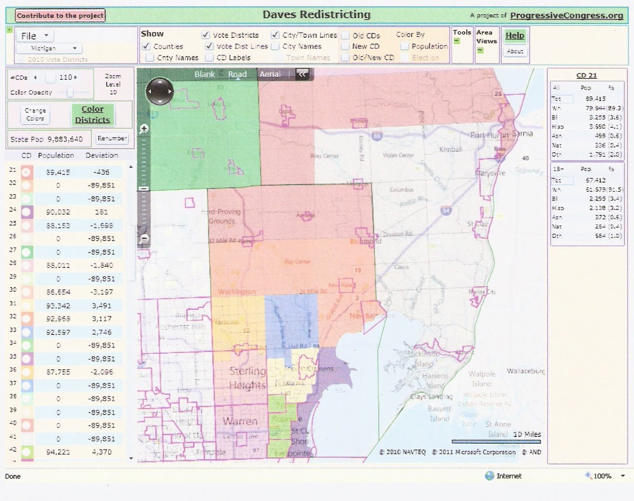
Michigan Redistricting: State House Part I: Wayne County In part III, we consider Macomb County. We have seen that districts in Wayne County can be drawn to avoid a break, and Lapeer County can constitute its own district. Since I grouped Oakland and Genesee together, either Macomb must be unbroken, or it must share districts with counties in the Thumb, particularly St. Clair. Currently Macomb has about 8.8 districts. It saw the largest numerical increase of any county in the state, gaining 52829 residents (ideally about .6 districts). Its ideal number of districts is now 9.36.
These new residents were not evenly distributed. Population gains were biggest in the `middle tier' townships. Macomb Township gained an incredible 29000 people, Shelby gained 8600, and Chesterfield 6000. Also, Sterling Heights gained 5000 and Washington gained 6000. North Macomb had stable population. South Macomb saw small losses, with Warren losing 4000, St. Clair Shores 3000, Eastpointe 2000. These losses occurred at the same time that south Macomb saw an influx of former Detroit residents moving to the suburbs.
One possibility for Macomb is to overpopulate its districts so that it has exactly nine. This would average a population of 93442. There are two problems with this. One is that overpopulated districts need to be balanced with underpopulated districts elsewhere in the state. This makes drawing the whole map difficult. The second problem is that not breaking Macomb leads to breaks in Sanilac and Tuscola.
Another possibility is to share 11 districts between Macomb and St. Clair. This gives an average of 91274, which is still pretty far over. It also leads to a break in Tuscola. Instead, I opted to combine Macomb, St. Clair, Sanilac, and Huron into 12 districts for an average population of 90021. This avoids any county breaks in the Thumb. City and township breaks must also be considered. There must be breaks in Warren, Sterling Heights, and Clinton due to population. There also must be a break either in or around Shelby. I have not found a map with fewer than five breaks (counting double breaks). Currently Macomb has 5 Republicans and 4 democrats. St. Clair and Sanilac have two more Republicans. Three of the Republican districts (St. Clair Shores/Harrison, Chesterfield, Sanilac/Port Huron) were held by democrats before 2010. A reasonable goal for a new map is to strengthen (or at least not weaken) all the vulnerable Republican districts and add a new Republican district in the growing areas. The `new' district is squeezed in to contain Port Huron, the second-to-the-top tier of townships, and the top tier of Macomb County. No district with Port Huron is completely safe, but this district is likely to elect a Republican. The Chesterfield district is shoved over to Washington, which should make it safe. Here is the map. There are breaks in Warren, Sterling Heights (double) and Clinton (double).
Ratings and descriptions for the map:
Rating: SR/LR/TU/LD/SD
Previous articles on Michigan redistricting: .
Share This:


Michigan Redistricting: State House Part III: Macomb and the Thumb | 0 comments ( topical, 0 hidden)
|

 |