|
NAVIGATION
|
NEWS TIPS!
RightMichigan.com

Who are the NERD fund donors Mr Snyder?Tweets about "#RightMi, -YoungLibertyMI, -dennislennox,"
 |
Michigan Redistricting: State House Part IV: The Rest of the StateBy Conservative First, Section News
Cross-posted at The Western Right
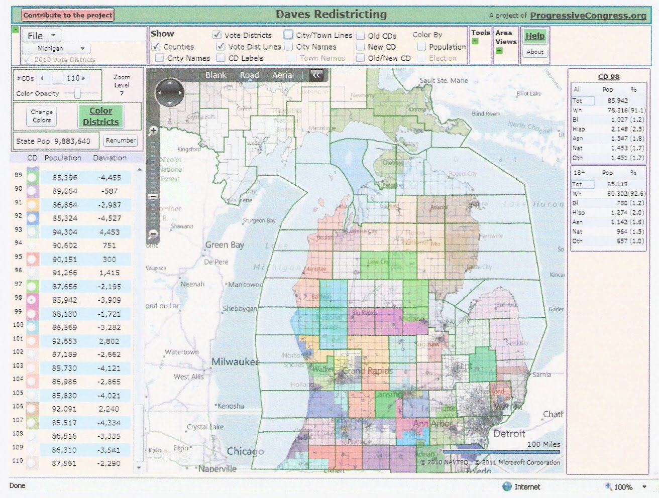
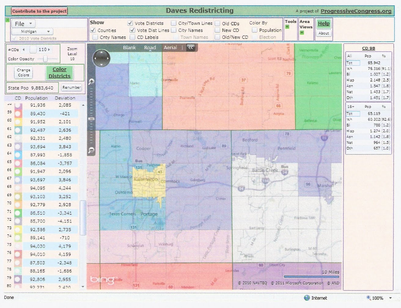
The three parts of my analysis of redistricting the Michigan state house focused on southeastern Michigan. This final part finishes the rest of the state. See the current map here: MICHIGAN'S 110 HOUSE DISTRICTS Let's look at the map first and then see where it came from.
.
 The new map must of course account for population shifts in the state. We have already seen that Wayne lost 240000 people, and hence will lose 3 state representatives. Other losses include 10000 each from Genesee and Saginaw. There were smaller losses in the Upper Peninsula, the Thumb, and the Sunrise Coast. The biggest gain was in Macomb with 53000. Other major gains include Kent with 28000, Ottawa with 25000, Washtenaw with 22000, Livingston with 14000, Kalamazoo with 12000, and Clinton with 11000. Smaller gains were scattered around western and southern Michigan. It is tricky to say which districts are `new', since each new district is made up of parts of old districts. But we can say definitely which regions gained districts. One went to Kent/Ottawa/Muskegon/Allegan/Kalamazoo, one went to Washtenaw/Monroe/Lenawee/Jackson/Eaton, and one went to a region containing Macomb and the north-central Lower Peninsula. The districts that I designated as `new' (21-23) are in S Kent/NE Allegan, Ann Arbor suburbs, and Port Huron/N Macomb. The first article above contains the basics on the rules that any map must follow. As before, we want to minimize county and city/township breaks. Hence when a county can contain some number of districts without being broken, it is usually a good idea to implement this. In this map, such counties are:
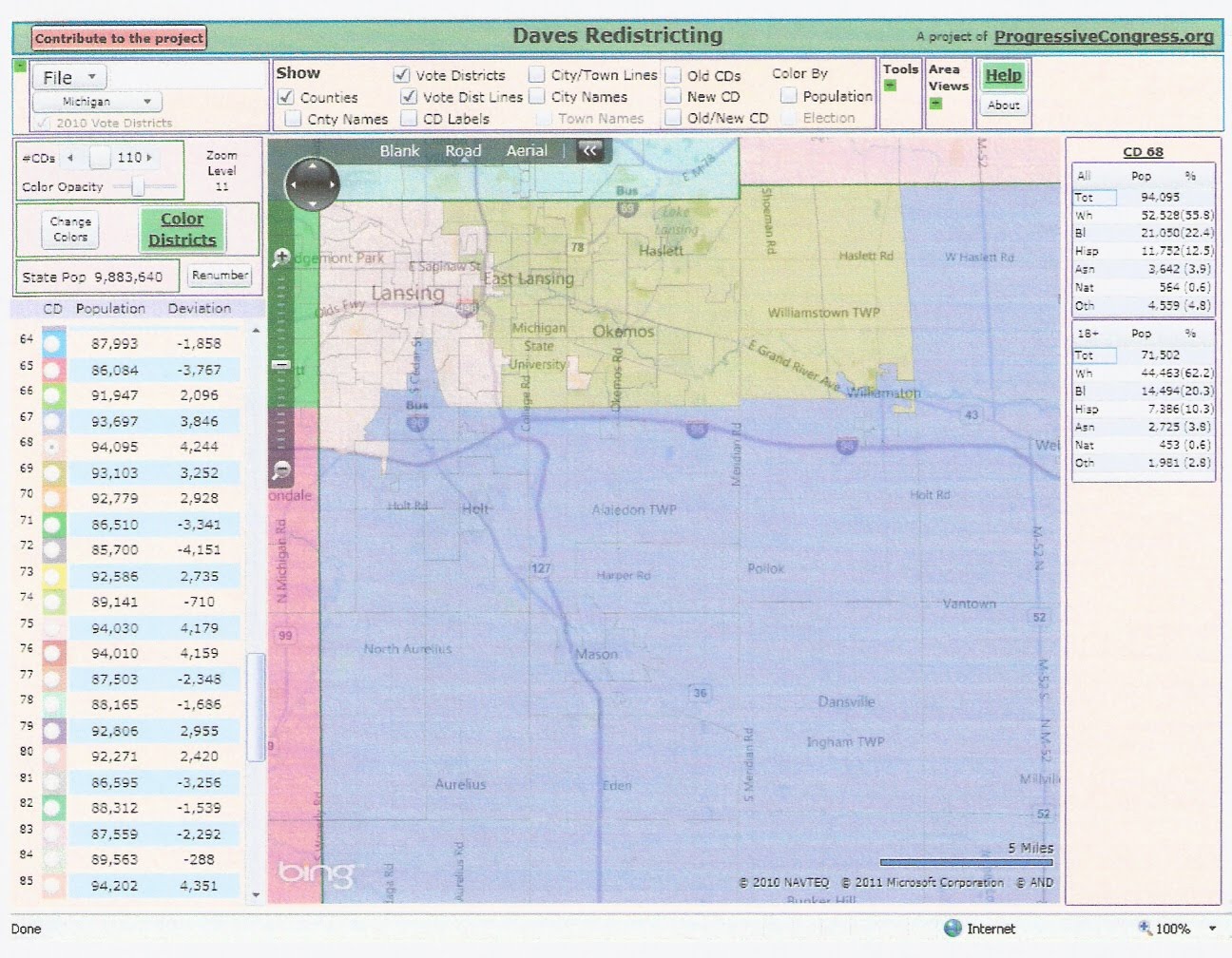
1 district: Lapeer, Grand Traverse These areas can be dealt with separately. SPECIFIC COUNTIES Drawing districts in Ingham is tricky because there appear to be several discontiguous precincts. The only district in this county that is winnable for Republicans is the out-county district (67), although it has been held by Byrums all decade. It is possible to marginally improve this district while maintaining one city break (Lansing) by taking a different chunk of Lansing. If two breaks are allowed, it can be made nearly safe by excising Lansing and replacing it with a chuck of Meridian.
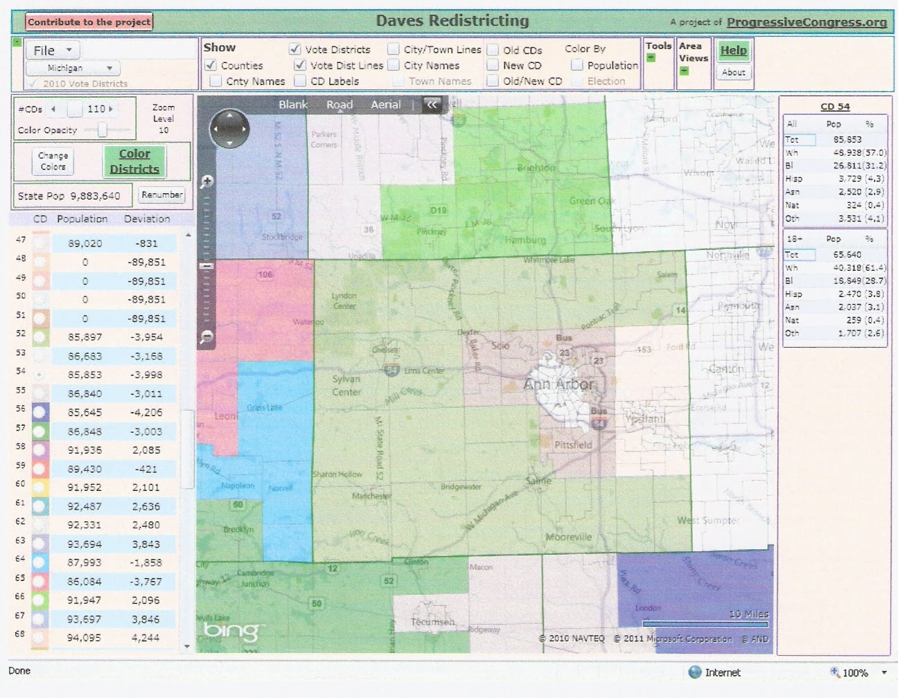
District 62 is a swing district dominated by Battle Creek. Improving it requires stripping out Albion, its only other dem area. Albion has to go to district 63 (Jase Bolger's district), making it a bit weaker, but still safe. Would the Speaker accept this for the good of the party? District 80 loses a chunk of Allegan and adds the southern tier of Kalamazoo.
The northeastern Lower Peninsula is carved up in a way that should be an improvement. District 105 adds the dem area of Presque Isle, but is still safe. District 106 takes in more of the Lake Huron coastline, but is no worse than before. The new 97, anchored by Missaukee and N Midland, is improved. The new 103, with Kalkaska and Otsego, is also improved. BREAKS, POPULATION, AND VOTING RIGHTS Overall, this map breaks 22 counties, including three double breaks (St. Clair, Jackson, Kalamazoo). The current map breaks 23 counties with two double breaks (St. Clair, Ottawa). This map also breaks 13 cities/townships, including breaking Detroit four ways and two double breaks (Sterling Heights, Clinton Twp). These breaks are in Wayne (5/8), Macomb (3/5), Oakland (2), Flint, Ann Arbor, and Lansing. The current map breaks 17 cities/townships, including a triple break for Detroit. These breaks are in Wayne (6/8), Macomb (4), Oakland (2), Genesee (2), Ann Arbor, Lansing, and Grand Rapids. The smallest district population is 85324 (district 92), which is just outside what is allowed and needs to be adjusted, perhaps by adding another break. Otherwise the smallest is 85396 (89). The largest district population is 94304 (93). There are 10 black-majority districts, down two from the current map due to population loss in Detroit. The number of black-majority districts could be increased by adding more breaks around Detroit, as seen in Part I. DISTRICT DESCRIPTIONS
Rating: SR/LR/TU/LD/SD Combined with the ratings for southeast Michigan, we have the following.
Rating: SR/LR/TU/LD/SD Thus this map is a definite improvement over the existing map. This is due mainly to population shifts, but also to careful line-drawing. Still, the map is not completely safe for Republicans. It would still have produced a democrat majority in a wave election like 2008. There are two reasons for this. First, state house elections are held in presidential election years, which are friendlier to democrats, as well as off years. State senate elections are only held in off years. Second, districts the size of house districts appear less easy to manipulate than districts the size of senate or congressional districts. It does not appear to be possible to make a totally safe house map absent massive gerrymandering. This map should give Republicans a majority in good or average years, which makes it good in my book.
Previous articles on Michigan redistricting: .
Share This:


Michigan Redistricting: State House Part IV: The Rest of the State | 5 comments (5 topical, 0 hidden)
Michigan Redistricting: State House Part IV: The Rest of the State | 5 comments (5 topical, 0 hidden)
|

 Related Links+ The Western Right+ Michigan Redistricting: State House Part I: Wayne County + Michigan Redistricting: State House Part II: Oakland and Genesee + Michigan Redistricting: State House Part III: Macomb and the Thumb + MICHIGAN'S 110 HOUSE DISTRICTS + + [2] + [3] + [4] + [5] + [6] + [7] + Michigan Congressional Redistricting: Two Possible Maps + Michigan Redistricting: Two Possible State Senate Maps + Also by Conservative First |