|
NAVIGATION
|
NEWS TIPS!
RightMichigan.com

Who are the NERD fund donors Mr Snyder?Tweets about "#RightMi, -YoungLibertyMI, -dennislennox,"
 |
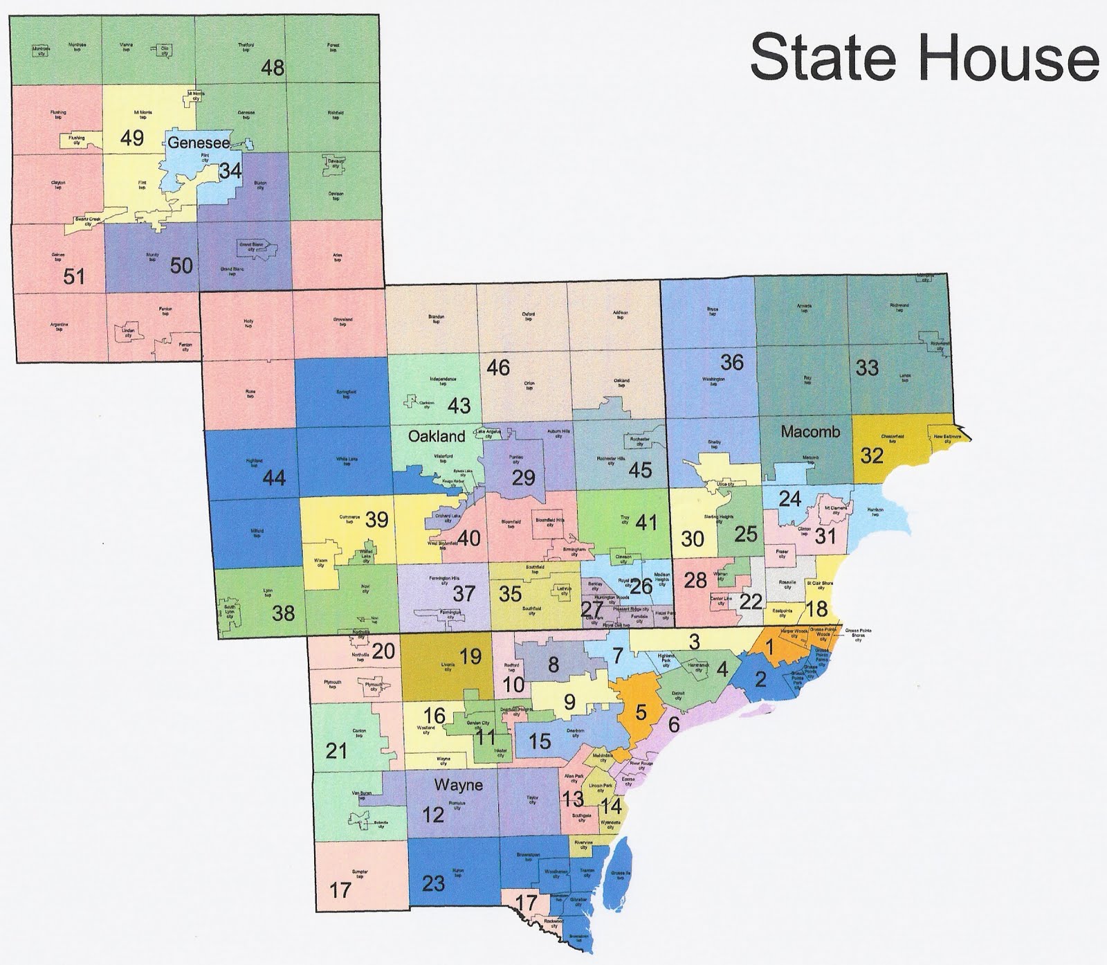
Michigan Redistricting: Alternative State House MapBy Conservative First, Section News
The legislative portion of Michigan redistricting is finished, assuming Governor Snyder signs the maps passed by the legislature. I have highly praised the congressional and state senate maps. The state house map is another story.
I proposed my own state house map in four parts here:
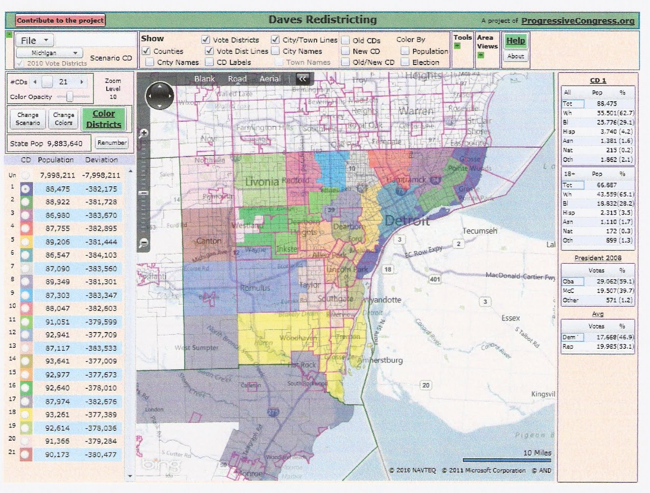
Michigan Redistricting: State House Part I: Wayne County The Republican state house map was quite a bit different. Part of this was due to the desire to protect existing districts. This led to districts being distributed differently in the Thumb, south-central Michigan, and the northeastern Lower Peninsula. Even on these terms, though, some parts of the map still perplex me. I decided to take another crack at the state house map. This time, I started with the Republican map and made changes in particular areas. Since my first map, Dave's Redistricting App has added some election data for Michigan, allowing for more precise analysis. I. Wayne County I don't know what Republicans were thinking in Wayne County. Currently Wayne has three Republicans. Two are strengthened under the new map. There is one more district containing the majority of Canton and Van Buren that is winnable.
The existing map has 23 districts in Wayne County. Due to population loss, the ideal number of Wayne districts is about 20.3 districts. I drew exactly 20 to avoid a county break, but the new map has about 20.3 and has a district overlapping parts of Monroe and south Wayne. This allows the Detroit districts to be slightly underpopulated, which makes it easier to maintain ten black-majority districts.
Here is the new Republican map.
Here is my alternative map.
There are several missed opportunities in the new map. 1. The district based in the Grosse Pointes was Republican until 2008. Demographics are tough here, as Harper Woods has rapidly become half-black and the district needs to gain population. The Grosse Pointes are a real "community of interest", and should not be split as they are in the new map. The only way to maintain a competitive district is to stretch it down to River Rouge and Ecorse, which are 20% Republican instead of 3% in Detroit. Admittedly, this is pushing it a bit, but the district has only one city break and the lines could be cleaned up by splitting a few precincts. This district is no better than a tossup (53.1% GOP average in 2006), but at least the GOP would have a chance here. Now this would eliminate one of the black-majority districts, but it can be replaced by a district (11) that stretches from Inkster through north Dearborn Heights to western Detroit.
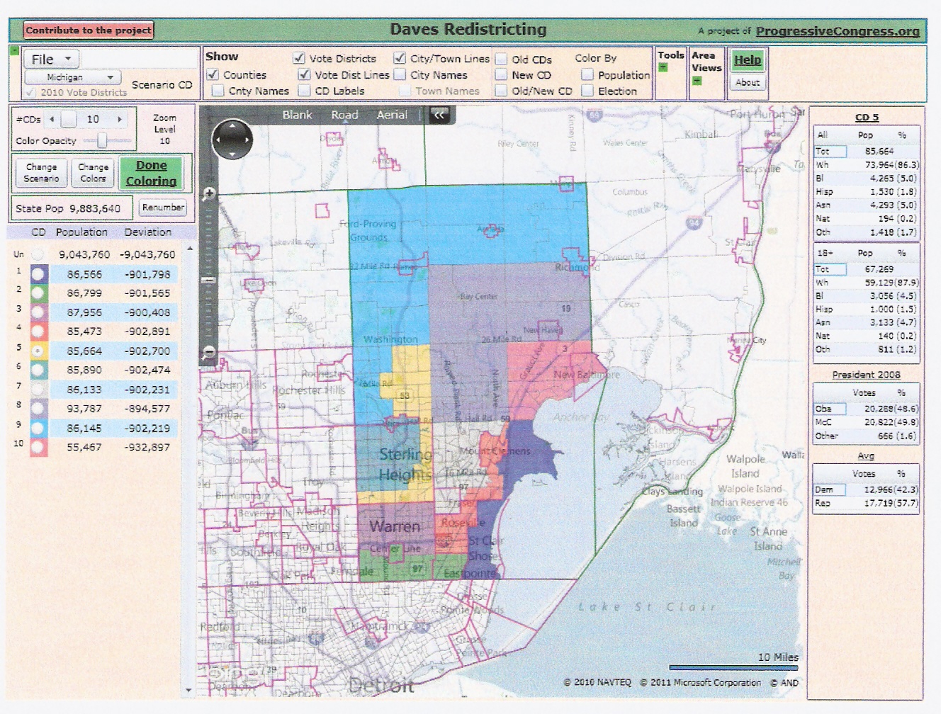
Rating: SR/LR/TU/LD/SD The alternative Wayne map would mean three more winnable districts than in the new map. It also complies better with the Apol standards than the GOP map. It breaks only five jurisdictions outside Detroit (Dearborn three ways), while the GOP map breaks six. Their map breaks Detroit seven ways, while mine breaks it only five ways. II. Macomb County Macomb currently has about 8.7 districts. Due to population growth, it is entitled to about 9.3 districts. The Republicans chose to slightly underpopulate the Macomb districts so that the Thumb districts would not be disrupted. Thus Macomb gets about 9.6 districts, with one containing Chesterfield and New Baltimore in Macomb and a chunk of St. Clair. That said, the GOP made major changes to several districts that have worked well for them the past decade. The Macomb delegation in the state house was 5R-4D all decade except for two districts that flipped in 2008 and flipped back in 2010. Here is the GOP map.
Here is my alternative map.
In the GOP map, the St. Clair Shores/Harrison district, which was Republican except in 2008 was split, with St. Clair Shores being stuck with Eastpointe in a safe D district. Sterling Heights is split east/west instead of north/south. The `east' district (25) includes a chunk of Warren and I rate it as a tossup. The north Warren/south Sterling Heights district was held by a Republican in the 90's, so it was winnable at least back then. My map packs all the most democrat areas into three districts. The St. Clair Shores/Harrison district is maintained, with one precinct from Clinton added for population. The Sterling Heights break is a little awkward because I wanted to put the most democrat precincts in with heavily Republican Shelby.
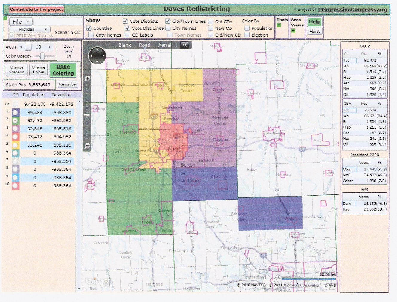
Old....... 3 / 2 / 0 / 0 / 4 GOP...... 4 / 1 / 1 / 0 / 4 ME:...... 3 / 4 / 0 / 0 / 3 My Macomb map complies better with the Apol standards. The GOP map breaks five jurisdictions, including a triple break of Warren. My alternative map breaks only four, including a triple break of Clinton. III. Genesee County Genesee County currently has five districts. Due to population loss, it is now entitled to about 4.6. Both my map and the GOP map have a district that overlaps Genesee and Oakland Counties. Our Oakland maps are similar and should lead to the same partisan outcome, but mine avoids breaking Waterford. My initial Genesee map was far from ideal. The initial version of the GOP map was pretty good, but it was amended to something that appears worse. Here are my calculations using the 2006 average. District 1 is whichever one contains Grand Blanc (Paul Scott's home). District two is the other winnable district.
Existing map:
 The only downside to my map is that Paul Scott and Bradford Jacobsen are put in the same district. But Scott is put in a lean D district in the final GOP map, and Jacobsen could move to an open safe district under my plan. Here are the overall ratings.
Rating: SR/LR/TU/LD/SD
Previous articles on Michigan redistricting:
Share This:


Michigan Redistricting: Alternative State House Map | 5 comments (5 topical, 0 hidden)
Michigan Redistricting: Alternative State House Map | 5 comments (5 topical, 0 hidden)
|

 Poll
Related Links+ Michigan Redistricting: State House Part I: Wayne County+ Michigan Redistricting: State House Part II: Oakland and Genesee + Michigan Redistricting: State House Part III: Macomb and the Thumb + Michigan Redistricting: State House Part IV: The Rest of the State + + [2] + [3] + My initial map + GOP initial map + GOP final map + [4] + Michigan Redistricting: Two Possible Congressional Maps + Michigan Redistricting: Two Possible State Senate Maps + Michigan Redistricting: Analysis of Democrats State Senate Plan + Michigan Redistricting: Official Republican State Senate Map Released + Michigan Redistricting: Official Republican State House Map Released + Michigan Redistricting: Republican State Senate Map Passed + Michigan Redistricting: Republican State House Map Passed + Michigan Redistricting: Congressional Map Passed + Also by Conservative First |
|||||||